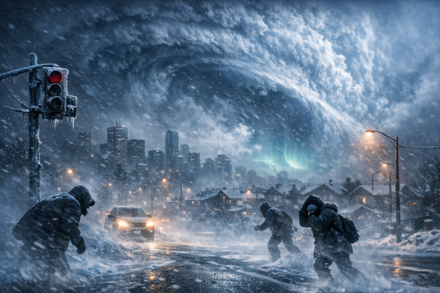
In a year already marked by wild weather patterns, scientists are sounding the alarm over a highly unusual event unfolding in the upper atmosphere. A dramatic disruption to the polar vortex — the swirling mass of frigid air that sits high above the Arctic — is reportedly developing at a scale and time of year that has rarely been seen before. For meteorologists and atmospheric experts, the sheer magnitude of this December disruption is nearly unprecedented and carries potential implications for millions of people across the Northern Hemisphere in the weeks to come.
Typically, December is a relatively stable month for the polar vortex. While occasional shifts happen, a full disruption of this magnitude tends not to occur until later in winter. Now, scientists warn that this early breakdown of the stratospheric vortex could unlock the Arctic’s icy grip and send polar air spiraling southward, possibly resulting in extreme cold waves and severe winter weather around the globe.
This rare atmospheric event has already led experts to draw comparisons with major historic cold spells. As global weather models begin to show signs of deep perturbations, meteorologists are racing to analyze the scope and timing of what may follow, especially in North America and northern Europe. What’s forming in the skies above could be a powerful disruptor of holiday forecasts and beyond.
Understanding the December Polar Vortex Disruption
| Event | Major Polar Vortex Disruption |
|---|---|
| Unusual Timing | December 2023 — earlier than typical events |
| Potential Impacts | Severe winter weather, polar cold outbreaks |
| Regions at Risk | North America, Europe, parts of Asia |
| Scientific Concern | Magnitude of disruption is extremely rare for December |
| Forecast Tools Involved | Stratospheric modeling, global circulation models |
What the polar vortex is and why it matters
The polar vortex is a large expanse of swirling cold air high in the stratosphere above the Arctic and Antarctic regions. It remains strongest during winter — when temperature contrasts between the polar region and mid-latitudes intensify — and helps contain icy air masses within the polar zones.
When the vortex is strong and stable, it tightly traps cold air above the Arctic, creating milder winter conditions in the mid-latitudes. However, when the vortex weakens or splits, it can spill freezing Arctic air southward, triggering cold snaps and winter storms across locations far from the poles.
Most years, any significant disruptions to this stratospheric phenomenon occur in *mid to late winter*, like January or February. That’s what makes this year so unusual — December vortex disruptions of this intensity hardly ever happen. As meteorologist Dr. Paul Winters noted:
This early disruption is striking and suggests a possible domino effect on global winter patterns much earlier than usual.
— Dr. Paul Winters, Senior Meteorologist
What changed this year
Experts say this year’s disruption is being driven by a combination of atmospheric wave activity, oceanic patterns, and temperature anomalies in the stratosphere. One possible contributor is an increase in upward-propagating waves from the troposphere, which exert pressure on the vortex by transferring energy vertically.
Another factor could be residual effects of ongoing El Niño conditions, which have been known to influence stratospheric circulation. When certain ocean-atmosphere oscillations align just right, they can send powerful wave energy into the Arctic region, destabilizing the vortex.
Additionally, unusually warm stratospheric temperatures developing at key pressure levels (10 hPa and 30 hPa) signal that a sudden stratospheric warming (SSW) event might be underway — a classic precursor to vortex breakdown.
What to expect in the coming weeks
While the exact downstream effects of a disrupted polar vortex are difficult to predict with precision, past events have shown that cold air outbreaks often begin 10–20 days after the initial disturbance. If that pattern holds, communities across North America and Europe could face increased risks of:
- Intense cold waves and Arctic blasts
- Heavy snowfall and ice storms
- Increased energy demand and infrastructure strain
- Flight cancellations and transit disruptions
Latest forecast models hint at a high-latitude blocking pattern, particularly between Greenland and northeastern Canada — a setup that often leads to a southward plunge of cold air into mid-latitude regions. Meteorologist Sarah Lee warns:
We’re watching for a major cold anomaly developing by late December into early January. This could rival or exceed some of the coldest periods in recent memory for parts of the U.S. and Europe.
— Sarah Lee, Climate Analyst
Why this event is so unusual
Historically, dramatic polar vortex disruptions have occurred a few times in modern records, most notably in February 2018 and January 2021. But the scale and timing of the current event — in December — makes it stand out.
Data from atmospheric sounding and satellite observations confirms early signs of vortex deformation and warming at 10 hPa — signs usually reserved for deep winter months. This makes it one of the earliest major disruptions of the vortex in decades.
This is like hitting the fast-forward button on winter. We’re seeing January-type atmospheric behavior before Christmas even arrives.
— Dr. Elena Morozova, Atmospheric Scientist
Which regions may be hit hardest
While a disrupted vortex doesn’t guarantee harsh winter weather everywhere, certain regions are more prone to feeling the effects. Based on current modeling, the following areas could see increased wintry impacts in late December and early January:
| Winners | Losers |
|---|---|
| Southern Europe — milder than usual | Northeast US — risk of Arctic outbreaks |
| Southwest Asia — stable conditions | Central & Northern Europe — snow potential high |
| Northwest Africa — warmer trend | Canadian Prairies & midwest USA — deep freeze risks |
It’s important to note that long-range forecasts remain probabilistic. While trends point toward increased winter severity in affected zones, there remains uncertainty on duration and extremity.
What this could mean for the rest of winter
If cold air becomes dislodged from the Arctic early, it can set the tone for a more prolonged or severe winter season. This domino effect may include recurrent snowfalls, prolonged freeze cycles, and risks to power infrastructure in vulnerable regions.
For governments, utilities, and farmers, an early warning of such a pattern shift can drive crucial preparation measures. Road salt stockpiling, energy load balancing, and emergency planning now take on new urgency.
Earlier-than-normal polar vortex changes create a longer window for winter-time volatility. This could affect everything from heating bills to agriculture output.
— Tom Reyes, Energy Risk Advisor
FAQs about the developing polar vortex disruption
What is a sudden stratospheric warming (SSW)?
An SSW occurs when temperatures in the stratosphere rise dramatically over a short period, often leading to disruption or reversal of the polar vortex. This can shift cold Arctic air into lower latitudes.
Why is a December vortex disruption so rare?
Most vortex breakdowns occur later in winter when atmospheric dynamics are more fully developed. A December disruption indicates early, aggressive atmospheric instability.
Can this lead to more snowstorms?
Yes, a weakened polar vortex can lead to increased snow potential as cold and moist air collide in mid-latitude locations across the U.S., Europe, and Asia.
Which U.S. states are most at risk?
Regions like the Midwest, Northeast, and Great Lakes states are more likely to experience Arctic outbreaks and possible blizzard conditions following such vortex disruptions.
How long could this cold pattern last?
Once the polar vortex weakens, cold air intrusions can persist for weeks. Secondary disruptions may also extend winter impacts into February or March.
Is global warming linked to these disruptions?
Some studies suggest a connection between Arctic warming and increased frequency of polar vortex instability, though the exact relationships remain debated among scientists.
What should I do to prepare?
Keep an eye on local forecasts, have emergency supplies on hand, winterize your home, and plan for possible delays or outages during severe conditions in late December or early January.