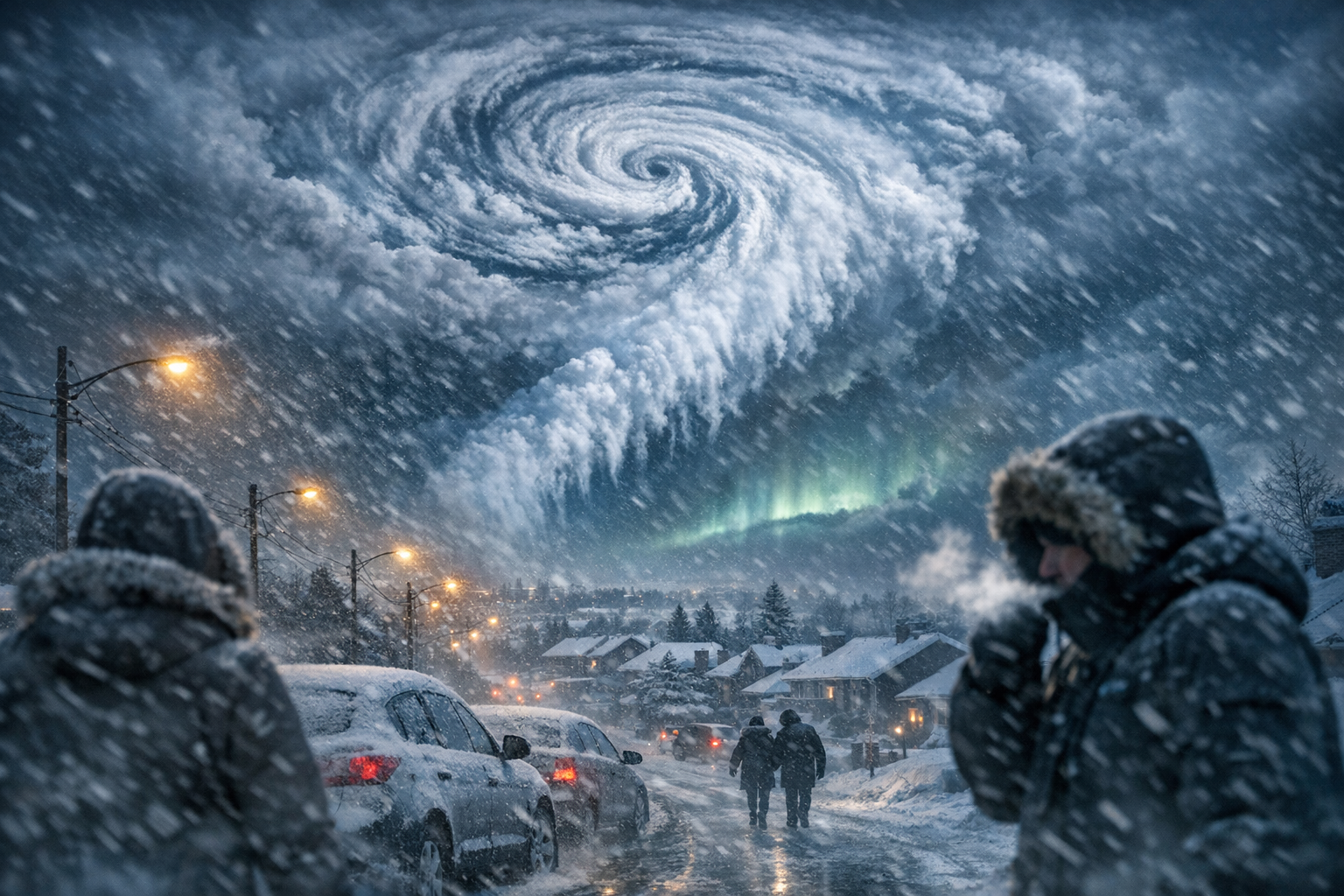
As winter grips the Northern Hemisphere, a remarkable atmospheric event is unfolding above our heads—one that could have sweeping consequences for millions in the coming weeks. Forecasters are closely watching the behavior of the **polar vortex**, a massive circulation of bitter cold air that typically swirls around the Arctic. Normally stable and contained, the polar vortex has recently shown signs of a dramatic and early-season disruption. And what’s truly startling is its **unusual magnitude for December**, a time when such disturbances are rare in the modern record.
This year’s developing polar vortex disruption could reshape how winter plays out from North America to Europe and East Asia. Historically, such events occur in the heart of winter—typically around January or February—but meteorologists now believe a significant disturbance is unfolding as early as mid-December. The last time anything similar happened was during anomalously cold winters decades ago. Experts say this disruption could send frigid Arctic air cascading farther south than usual, resulting in more frequent **cold waves**, snowstorms, and sustained freezes.
Understanding this phenomenon is not only a scientific challenge but also a logistical one. With energy grids balking under demand and emergency services already stretched across the globe, the ripple effect of an anomalous polar vortex could be substantial. Here’s what to expect in the coming weeks, how it may affect regions globally, and what climatologists are saying about this rare atmospheric twist.
Overview of the Polar Vortex Disruption
| Phenomenon | Polar Vortex Disruption |
| Timing | Mid to Late December 2023 |
| Cause | Sudden Stratospheric Warming and Jet Stream Shifts |
| Possible Impacts | Severe cold outbreaks across North America, Europe, and parts of Asia |
| Historical Rarity | Most significant December disruption in recent decades |
What changed this year
In most winters, the polar vortex acts like a tight loop of air trapping the coldest temperatures around the North Pole. It acts essentially as a “lid” on frigid air masses, stopping them from plunging too far south. However, when the polar vortex becomes disrupted—whether through **sudden stratospheric warming** or by waves in the jet stream—that lid weakens, allowing icy Arctic air to spill into lower latitudes.
This December, scientists have detected what they describe as major **wave forcing**—a movement in atmospheric patterns that presses unusually high amounts of energy upward from the troposphere into the stratosphere. That energy is now warping and weakening the polar vortex from within. It’s still early in the cold season for such dynamics, which is precisely why the development has captured so much attention among meteorologists.
“We typically see these kinds of events in January or February. A disruption of this scale in December is virtually unheard of in the satellite record.”
— Dr. Emily Rand, Atmospheric Scientist
Why this event could cause extreme winter conditions
When the vortex weakens or becomes dislocated, the impacts trickle down quickly. North America, Europe, and Asia are historically vulnerable to polar vortex instability. During disruptions, the Arctic air mass can break off and slide into the Midwest, Eastern Seaboard, or deep into continental Europe. This often results in **arctic outbreaks**, longer and more extreme cold spells, and even a change in **storm track positioning**, leading to snowier conditions.
“Disruptions of the stratospheric polar vortex have downstream effects—meaning they don’t just stay up there. They can drastically reshape surface weather within seven to ten days.”
— Dr. Karen Zhao, Climate Dynamics Researcher
Experts warn that depending on the strength of the ongoing disruption, areas from **New York** to **Berlin**, **Moscow**, and parts of **East Asia** could see sub-normal temperatures well into January 2024. The increased **polar jet stream meandering** also sets up favorable conditions for winter storms, including Nor’easter systems along the U.S. East Coast.
How rare are December polar vortex disruptions
In the scope of satellite observations spanning about four decades, major disruptions of the polar vortex in December are exceedingly rare. Typically, early-season vortex disruptions are weak or localized. The current models, however, indicate something far stronger and more coherent.
The 1984/1985 winter is often pointed to as a historical analog. That season saw record-shattering cold across parts of the U.S. and Europe, following an early disruption of the polar vortex. While not a guarantee of replication, the comparison serves as a caution for what might lie ahead if trends continue similarly in December 2023.
Regions most likely to be affected
While long-range forecasts are never guarantees, certain geographic areas consistently show historical impact from polar vortex splits or collapses.
- North America: Midwest, Northeast U.S., and parts of Canada may see extended cold snaps and snow events.
- Europe: Continental regions, the UK, and Scandinavia may experience high-pressure blocks that funnel in Arctic air.
- East Asia: Parts of China, Korea, and Japan have seen substantial cold waves during vortex instability in past years.
“Expect temperature anomalies to trend downward in these zones by late December, particularly as the vortex wave pattern cascades downward.”
— Dr. Suresh Raman, Jet Stream Modeler
What sectors and systems are at risk
Winter affects more than bundled-up pedestrians. National infrastructure, agriculture, and energy systems could be seriously strained by early and unexpected cold waves.
- Energy Grids: Increased heating demand during persistent cold spells could test electricity and gas reliability.
- Agriculture: Crops and livestock not acclimatized to Arctic-style temperatures this early in winter could be vulnerable.
- Healthcare: Cold stress incidents, respiratory infections, and hypothermia cases tend to spike during prolonged freeze conditions.
- Transport: Aviation and shipping disruptions related to snow and ice could escalate across affected regions.
Winners and losers from the early polar vortex shift
| Winners | Losers |
|---|---|
| Winter tourism operators in ski and snow resort destinations | Commuters, travelers, and the airline industry |
| Energy traders positioned for high demand | Agricultural producers with sensitive crops and livestock |
| Cold-weather sporting goods retailers | City infrastructure managers handling snow and ice |
Signals to watch in the coming weeks
For those following this phenomenon—whether for scientific, preparedness, or economic reasons—there are certain signals to monitor:
- Stratospheric temperature anomalies: Warming anomalies at 10 hPa level can indicate the strength of disruption.
- AO (Arctic Oscillation) Index: A negative phase often follows polar vortex splits, favoring cold air outbreaks.
- Jet stream patterns: Look for meandering and southward dips that can push Arctic air to mid-latitudes.
Should we be concerned or prepared?
The answer is yes—but with nuance. While it’s impossible to predict each storm or cold snap weeks in advance, the conditions now forming in the stratosphere warrant heightened awareness. Citizens, municipalities, and energy sectors would do well to plan for above-average heating demand, transportation delays, and potential emergency responses to severe cold.
As new data emerges, forecasts will be refined. In the meantime, staying informed about upper-atmospheric developments may provide a vital edge in anticipating the shape of this coming winter.
Frequently Asked Questions
What is the polar vortex?
The polar vortex is a large area of low pressure and cold air surrounding the Earth’s poles. It typically keeps the coldest air trapped near the polar regions unless it’s disrupted.
What causes polar vortex disruptions?
These are typically triggered by sudden stratospheric warming events or disruptions in wind patterns like planetary waves that weaken or displace the vortex.
How does a disrupted vortex affect the weather?
A disrupted vortex can allow cold Arctic air to move southward into regions that are usually milder, leading to unusually severe winter weather.
Why is a December disruption rare?
The stratosphere is usually more stable in early winter. Most disruptions occur in late January or February, making a December event unusual and potentially more impactful.
Is this disruption linked to climate change?
The connection is still debated. Some research suggests that warming Arctic conditions may be making the polar vortex more prone to instability over time.
What can individuals do to prepare?
Monitor local forecasts, winterize homes and vehicles, stock emergency supplies, and be cautious when traveling during expected cold waves or snow events.
How soon could impacts be felt?
Surface impacts from stratospheric disturbances often manifest within 7 to 14 days, meaning changes could be noticeable by late December.
Could this mean more snow this season?
Possibly. A disrupted vortex can influence storm tracks, potentially leading to increased snowfall in certain regions where cold air collides with moist systems.