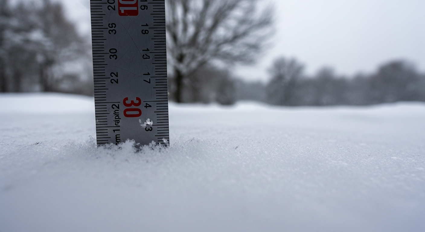
As the nation braces for another wave of extreme winter weather, meteorologists are issuing urgent alerts about rapidly intensifying snowstorms sweeping across multiple regions. The latest forecast brings escalating concerns as snowfall predictions have surged, with up to **30 centimeters** of accumulation expected in some areas. Alongside the heavy snow, detailed **hour-by-hour timing breakdowns** offer critical guidance for residents and municipalities preparing for the incoming storm front. The enhanced alerts cover a broad swath of territory, from eastern seaboard cities to inland towns, spotlighting a widespread event that is poised to impact millions of daily lives.
Experts stress the importance of immediate action, urging local governments, emergency responders, schools, and families to prepare accordingly. Heavy snow accumulation could cause **significant traffic disruptions**, power outages, and school closures. Local authorities have initiated pre-treatment of major highways and are ramping up operations to deal with the anticipated scale of the storm. Meanwhile, the public is advised to stock up on essentials and stay closely attuned to changing conditions. To help people navigate the uncertainty, meteorologists have issued a detailed **regional snowfall timeline**, offering invaluable insight into when and where impacts will hit hardest.
Key details about the snowstorm outlook
| Forecast Element | Details |
|---|---|
| Total Accumulation | Up to 30 cm in parts of the Northeast and mid-Atlantic |
| Region Most Impacted | Upper New York, Pennsylvania, Northern New Jersey, parts of New England |
| Start Time | Tuesday, 4 a.m., moving west to east |
| Peak Snowfall | Tuesday afternoon to Wednesday morning |
| Weather Alerts Issued | Winter Storm Warnings, Snowfall Watches, Hazardous Travel Advisories |
| Main Concerns | Heavy snow, reduced visibility, power outages, transportation delays |
What changed this year
Unlike milder winters of recent memory, this season has unfolded with rapidly shifting cold fronts and an active polar jet stream, leading to more frequent and powerful snow systems. This specific storm is being intensified by **arctic air** from the northwest clashing with **moist Atlantic air**, creating a prime environment for snow formation. Meteorologists say that the current storm model is evolving faster than typical patterns, increasing the complexity of regional impacts and timelines.
The National Weather Service confirmed this storm is being driven by unusual low-pressure activity centered over the Great Lakes, enhancing snowfall rates particularly in elevated terrains and inland valleys. Changes to precipitation types—such as snow turning briefly to sleet or rain and back to snow—may affect accumulation totals and make forecasting even more challenging in transition zones.
Regional timing and accumulation breakdown
Experts have released a detailed projected schedule based on the latest radar and meteorological modeling. Timing varies slightly depending on elevation and proximity to the storm’s epicenter, but the general forecast shows a clear progression from early morning Tuesday into midweek.
- New York City and Surrounding Areas: Snow expected to begin around 6:00 a.m. Tuesday, peaking by mid-afternoon with accumulation of up to 18 cm. Travel disruptions likely during evening rush hour.
- Philadelphia and South Jersey: Snow arrives slightly earlier, by 5:00 a.m. Tuesday, mixed with sleet by midday, then pure snow overnight. Up to 20 cm expected in inland locations.
- Boston and New England Corridor: Snow onset around 9:00 a.m. Tuesday, intensifying by late afternoon. Expect full storm impact from evening through early Wednesday, with snow totals ranging between 15–28 cm.
- Western Pennsylvania / Appalachians: First snowbands begin around 3:00 a.m., continuing steadily. Elevation aiding heavier snowfall; up to 30 cm in mountainous regions.
Why schools and commuters need to prepare now
Given the timing and severity of the storm, schools are expected to announce **closures or remote learning shifts** in large numbers. The early start on Tuesday means parts of the morning commute will already be disrupted, escalating into hazardous conditions by early afternoon. Transportation officials recommend teleworking where possible and avoiding non-essential trips through Wednesday morning.
Commuter rail and bus services in affected regions are also adjusting schedules, with many agencies planning pre-emptive suspensions. Airlines operating in and out of key hubs like JFK, Newark, and Boston Logan are issuing change fee waivers and beginning to cancel Tuesday arrivals and departures.
Emergency services and local government response
City and county officials have activated emergency operation centers across impacted zones. Snowplows have been pre-deployed, and road salt application began as early as Sunday night in some jurisdictions. Authorities also remind residents to **clear sidewalks and hydrants**, assist elderly neighbors, and prepare emergency kits at home.
We’ve escalated to Level 2 Emergency Operations across six counties. This storm has the potential to significantly impact safety if people don’t prepare.
— Amanda Fisher, State Emergency Management Director
Some municipalities have also declared snow emergencies, restricting street parking to allow efficient snow removal. Warming centers and shelters are being opened in anticipation of potential power outages or pedestrian safety hazards during extreme cold temperatures post-storm.
Comparing to historic winter events
Meteorologists are drawing early comparisons between this storm and past impactful blizzards such as the 2015 snowstorm in the Northeast, which resulted in widespread closures and lengthy recovery times. While not all regions will reach record-breaking numbers, the sheer **geographic breadth** and **timing** of this system may create a greater collective disruption across the Eastern seaboard.
With field reports confirming that snow-to-liquid ratios are higher under current cold air dynamics, even moderate moisture content is leading to heavier snow loads. That could increase the burden on power lines and risk roof stress in older structures with inadequate insulation.
Winners and losers depending on storm location
| Winners | Losers |
|---|---|
| Snowplow contractors with peak demand | Airline travelers facing cancellations |
| Ski resorts benefitting from fresh powder | Commuters and delivery drivers |
| Children anticipating school closures | Small businesses losing foot traffic |
| Grocery stores with increased sales | Outdoor workers exposed to harsh conditions |
General safety tips for impacted households
Authorities are advising residents to follow common but important safety precautions:
- Charge all phones, flashlights, and backup batteries.
- Stock enough food, water, and medications for 3 days.
- Stay off the roads during peak snowfall hours.
- Avoid using gas stoves or grills indoors for warmth.
- Shovel walkways in stages to avoid strain or injury.
- Watch for signs of frostbite and hypothermia, particularly in children and the elderly.
Timely preparation could be the difference between inconvenience and catastrophe. Don’t underestimate how quickly conditions can change.
— Dr. Caleb Monroe, Lead Forecaster at National Weather Research Center
Frequently asked questions about the upcoming snowstorm
How much snow is expected to fall during this storm?
Some areas, particularly in the Northeast and mountainous inland regions, may receive up to **30 cm** of snow. Lower totals are likely closer to coastal zones.
When will the snow begin and end?
The snow is expected to start early Tuesday morning and continue through Wednesday morning. Peak accumulation will occur late Tuesday into early Wednesday.
Will schools be closed?
Many school districts are expected to announce closures or switch to remote learning. Parents should monitor local alerts and school district notices closely.
Are flights being canceled because of the snow?
Yes, several airlines have already begun issuing travel advisories and cancellation notices. Check directly with your carrier for the latest information.
What regions are at greatest risk for severe snow impact?
Upper New York, inland Pennsylvania, parts of Northern New Jersey, and western New England are forecasted to bear the brunt of accumulation and related hazards.
How can I prepare my home for the snowstorm?
Ensure you have enough food, water, flashlights, and batteries. Avoid travel during peak hours, and have a plan in case of extended power outages.
Will this storm cause power outages?
Potentially yes. The heavy, wet snow can damage power lines, especially in heavily treed or elevated areas. Utility crews are on standby, but total restoration may take time.
Should I be worried about flooding after the snow?
In areas where temperatures rise rapidly after the storm, there could be localized flooding due to melting snow. Monitor forecasts and drainage conditions carefully.