Devastating Cyclone Set to Strike Brazil: Meteorologists Issue Urgent Warnings
The tranquil skies over southern Brazil are about to transform into a meteorological nightmare. As millions of Brazilians brace themselves for what could be one of the most significant weather events of the year, meteorologists are sounding alarm bells about a powerful cyclone system that’s already showing signs of formation. The brazil cyclone forecast paints a stark picture of nature’s raw power preparing to unleash itself upon unsuspecting communities.
Families across Rio Grande do Sul, Santa Catarina, and Paraná are facing a cruel twist of fate. After enduring days of suffocating heat that has pushed temperatures to a scorching 40°C in some areas, they now must prepare for the opposite extreme. The meteorological whiplash threatens to catch residents off guard, transforming their sweltering reality into a storm-battered landscape within mere hours.
The emotional toll on communities cannot be understated. Parents are already making difficult decisions about their children’s safety, while elderly residents remember similar storms from decades past that forever changed their neighborhoods. Local emergency services are working around the clock, knowing that the window for preparation is rapidly closing.
What makes this situation particularly heart-wrenching is the timing. Just as people were seeking relief from the oppressive heat wave, they must now batten down the hatches for potentially destructive storms, flooding, and dangerous wind conditions that could persist for days.
Critical Timeline: When the Cyclone Will Strike
The brazil cyclone forecast reveals a precise timeline that meteorologists are monitoring with growing concern:
- Tuesday, January 27: First isolated thunderstorms emerge in Paraná, signaling the beginning of atmospheric instability
- Wednesday, January 28: Storm risk expands across southern regions with intense afternoon and evening downpours
- Thursday, January 29: Widespread storms engulf much of southern Brazil as weather systems organize near the Argentine border
- Friday, January 30: Heavy rain and thunderstorms shift eastward toward the Atlantic coast
- Saturday, January 31: New cyclone officially forms off the Brazilian coast between South and Southeast regions
Regions Under Immediate Threat
The meteorological analysis identifies several high-risk areas that face the most severe impacts:
- Western Rio Grande do Sul: Expected to experience the most intense early-morning episodes with strong wind gusts
- Campanha Region: Under severe storm alert with potential for lightning and heavy rainfall
- Central-Western Santa Catarina: Facing afternoon and evening storm systems
- Paraná Interior: Anticipating widespread thunderstorm activity
- Uruguaiana Area: Projected to see the most violent early-day episodes
- Coastal Areas: Atlantic-facing regions preparing for cyclone formation impacts
Current Heat Wave Conditions
| Region | Maximum Temperature | Duration | Humidity Impact |
|---|---|---|---|
| Rio Grande do Sul (Western) | Above 36°C daily | Until Wednesday | Extreme “sauna” effect |
| Santa Catarina (Interior) | Approaching 40°C | Through mid-week | High humidity levels |
| Paraná (Central) | 35-38°C range | Until Thursday | Suffocating conditions |
| Southeast (Parts) | Well above average | Variable | Moderate to high |
“The contrast between the current heat wave and the incoming cyclone system creates a perfect storm scenario. We’re seeing tropical air masses colliding with cooler systems from higher latitudes, which historically produces some of our most severe weather events,” explained Dr. Maria Santos, Chief Meteorologist at the Brazilian National Weather Service.
Cyclone Formation Mechanism
Understanding how this brazil cyclone forecast developed helps explain why meteorologists are so concerned. The cyclone formation process involves several critical factors working in dangerous harmony.
The system draws its energy from the dramatic temperature contrasts currently building across the region. Warm, humid tropical air masses are being forced to interact with significantly cooler air pushing up from southern latitudes. This creates instability in the atmosphere that manifests as rotating storm systems.
Over the Atlantic Ocean, these contrasting air masses find the perfect breeding ground. The warm ocean waters provide additional energy, while the Coriolis effect helps organize the system into a coherent cyclonic pattern. Meteorologists are particularly concerned about the rapid intensification potential as the system moves over increasingly warm coastal waters.
“What we’re observing is a textbook example of how extreme weather systems develop. The current heat wave isn’t just uncomfortable – it’s literally fueling the cyclone formation. The more intense the heat, the more dramatic the eventual weather transition becomes,” stated Professor João Silva from the University of São Paulo’s Atmospheric Sciences Department.
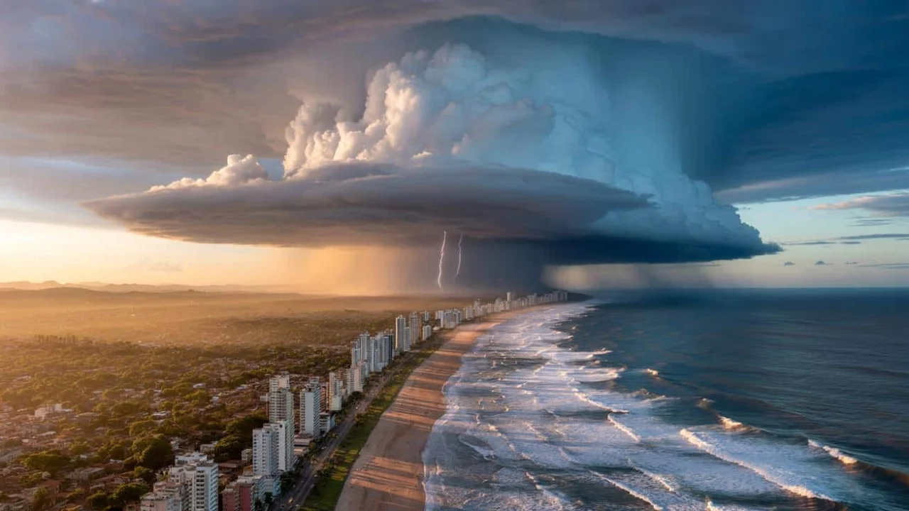
Expected Storm Characteristics
The incoming weather system promises to deliver multiple dangerous elements simultaneously:
- Intense Rainfall: Short-duration but extremely heavy downpours capable of causing flash flooding
- Lightning Activity: Frequent and dangerous electrical activity across affected regions
- Wind Gusts: Potentially destructive wind speeds, especially in exposed areas
- Temperature Drops: Sudden and dramatic cooling following the current heat wave
- Hail Potential: Severe thunderstorms may produce damaging hailstones
- Coastal Impacts: Storm surge and dangerous surf conditions along the Atlantic
Regional Emergency Preparations
Local authorities across southern Brazil are implementing comprehensive emergency protocols. The brazil cyclone forecast has triggered coordinated response efforts involving multiple government agencies, emergency services, and community organizations.
Emergency shelters are being prepared in high-risk areas, while utility companies are positioning repair crews for rapid response to power outages. Agricultural communities face particular challenges, as the combination of extreme heat followed by severe storms threatens both livestock and crops.
Transportation networks are also preparing for significant disruptions. Airlines are already adjusting flight schedules, while highway authorities are positioning emergency equipment along major routes that could experience flooding or wind damage.
“Our emergency response teams have been activated and are coordinating with meteorological services to ensure we’re prepared for all scenarios. The public’s cooperation in following safety guidelines will be crucial in minimizing the impact of this weather system,” announced Civil Defense Coordinator Carlos Rodriguez during a press briefing.
Historical Context and Climate Patterns
This cyclone formation fits within broader patterns that meteorologists have observed in recent years. Climate variability in the South Atlantic has been increasing, leading to more frequent and intense weather extremes across the region.
Historical data shows that similar heat wave-to-cyclone transitions have produced some of Brazil’s most memorable weather events. The combination of atmospheric instability and oceanic energy often results in systems that exceed initial forecasting predictions.
Researchers note that while cyclones in the South Atlantic are relatively uncommon compared to other ocean basins, when they do form, they tend to be particularly impactful due to the unique geographical and meteorological characteristics of the region.
Safety Recommendations and Preparations
As the countdown to cyclone impact continues, residents across the affected regions should prioritize immediate safety preparations:
- Secure Property: Remove or secure outdoor furniture, decorations, and loose materials
- Emergency Supplies: Stock adequate water, non-perishable food, flashlights, and batteries
- Communication Plans: Ensure family members know how to contact each other during emergencies
- Evacuation Routes: Identify and practice evacuation routes from flood-prone areas
- Medical Needs: Ensure prescription medications and medical supplies are available
- Vehicle Preparation: Keep vehicles fueled and avoid driving during severe weather
Frequently Asked Questions
When will the cyclone make landfall in Brazil?
The cyclone is expected to form between Friday and Saturday, with coastal impacts beginning immediately thereafter.
Which areas face the highest risk from this storm system?
Western Rio Grande do Sul, coastal Santa Catarina, and eastern Paraná are under the highest threat levels.
How long will the severe weather conditions persist?
Storm conditions may last through the weekend, with gradual improvement expected by early next week.
Should residents evacuate from coastal areas?
Follow local emergency management guidance, as evacuation recommendations vary by specific location and risk level.
Will this cyclone be stronger than previous systems?
Current models suggest moderate to strong intensity, but rapid changes are possible as the system develops.
How can people stay updated on the latest forecasts?
Monitor official meteorological services, local emergency management, and reliable news sources for continuous updates.
As Brazil prepares for this significant weather event, the importance of community preparedness and individual responsibility cannot be overstated. The transition from extreme heat to potentially destructive storms represents one of nature’s most challenging tests, requiring both meteorological expertise and human resilience to navigate successfully.