| Key Aspect | Current Status | What This Means |
|---|---|---|
| Polar Vortex Disruption | Rare early-season sudden stratospheric warming event underway | February could bring severe cold waves and wild temperature swings |
| Temperature Change | Arctic air 30km up heating by 40-50°C in days | Weakened vortex allows Arctic air to spill into populated regions |
| Timeline | Effects typically reach surface 1-3 weeks after stratospheric event | Late January disruption targets February weather patterns |
| Geographic Impact | Models show vortex displacement toward North America and Eurasia | Cities from Chicago to Berlin face potential extreme cold outbreaks |
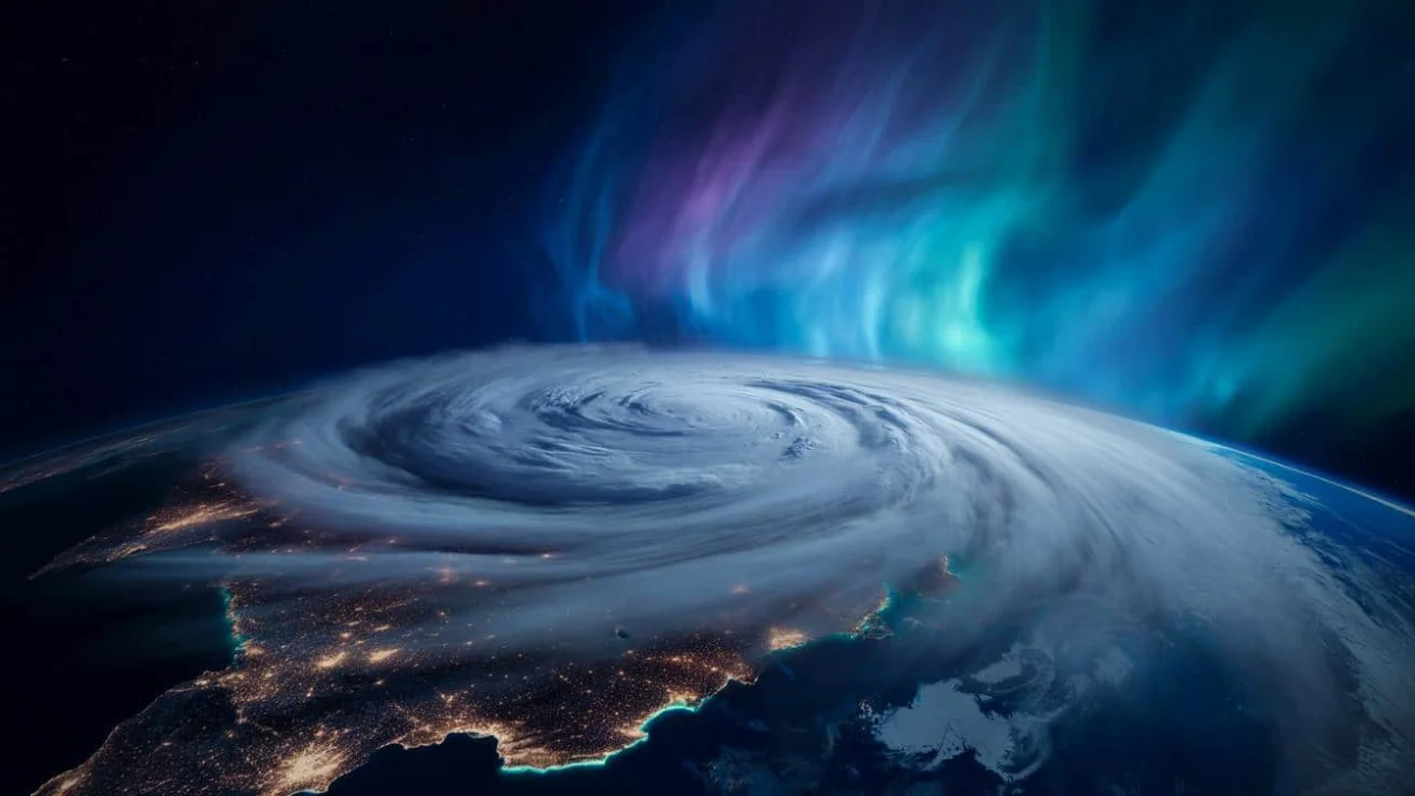
Meteorologists are watching something extraordinary unfold 30 kilometers above the Arctic. A sudden stratospheric warming event is tearing apart the polar vortex in ways rarely seen this early in winter, setting up what could be February’s most dramatic weather story in years.
The invisible ring of icy winds that normally keeps Arctic air locked near the North Pole is wobbling and weakening. When this atmospheric fortress collapses, the consequences ripple down to street level where millions of people walk dogs, drive to work, and heat their homes with no idea that their February is being rewritten by forces tens of thousands of feet overhead.
Arctic Atmosphere Breaks Apart in Rare Display
High above the North Pole, temperatures are spiking by 40 to 50 degrees Celsius in just days. This isn’t surface weather — it’s happening in the stratosphere, where the polar vortex normally spins like a tightly wound top, keeping Arctic air contained.
The numbers tell a stark story. Weather models are lighting up with splashes of red and purple, showing unprecedented heating in a layer of atmosphere that’s supposed to stay brutally cold. The vortex is being squeezed like a balloon, attacked by waves of warmer air surging up from lower latitudes.
What makes this event particularly concerning is its timing. Early-season disruptions typically give the vortex time to recover before significantly affecting surface weather. This year’s sudden stratospheric warming is hitting during late January, positioning it perfectly to steer winter’s final act through February.
Who Faces the Harshest Impact
The displaced polar vortex doesn’t affect everyone equally. Forecast models suggest these regions face the highest risk:
- ✓ Major cities across the U.S. Midwest and Northeast
- ✓ European population centers from London to Moscow
- ✓ Parts of East Asia, particularly northern China and Japan
- ✓ Canadian provinces from Ontario to the Maritimes
- ✓ Areas that have experienced unusually mild winter weather so far
“We’re seeing atmospheric signatures that remind me of 2013-2014 and 2018 — winters that people still talk about,” says a senior atmospheric scientist tracking the event. “The difference is this disruption is happening earlier, which could make February more intense than those benchmark years.”
Historical Winters Show the Potential Damage
Past polar vortex collapses have left lasting marks on both weather records and public memory. The 2013-2014 winter brought Chicago temperatures so cold that exposed skin froze in minutes. Photos of boiling water thrown into the air turning instantly to ice went viral across social media.
That winter wasn’t just meteorologically extreme — it was culturally sticky. Energy grids strained under unprecedented demand. Schools shuttered for days. Transportation networks froze solid, stranding travelers and disrupting supply chains worth billions of dollars.
The 2018 event delivered similar chaos to Europe. Rail lines froze across multiple countries. London saw its heaviest snowfall in years. Energy prices spiked as demand soared and supply infrastructure struggled with conditions it wasn’t designed to handle.
| Previous Event | Key Impact | Geographic Reach |
|---|---|---|
| 2013-2014 Polar Vortex | Record cold across U.S., -37°F in Chicago | Eastern U.S., parts of Canada |
| 2018 “Beast from the East” | Heavy snow, transportation chaos in Europe | UK, Western Europe, parts of Asia |
| 2009 Winter Disruption | Extended cold period, energy infrastructure strain | Northern Europe, Russia |
| Current 2025 Event | TBD – Models suggest widespread cold waves | North America, Europe, East Asia |
February’s Weather Patterns Face Complete Restructuring
This isn’t just about cold temperatures. A disrupted polar vortex reshapes entire weather patterns, creating what meteorologists call “meridional flow” — a wavy jet stream that allows Arctic air to plunge far south while warm air surges north in other locations.
The practical impacts cascade through daily life:
- ✓ Sudden temperature drops of 15-20°F overnight
- ✓ Surprise snowstorms in areas expecting mild weather
- ✓ Frozen pipes in buildings not designed for extreme cold
- ✓ Transportation delays and cancellations
- ✓ Energy grid strain from massive heating demand spikes
- ✓ School closures and childcare disruptions
The emotional toll shouldn’t be underestimated either. People rely on seasonal predictability for everything from vacation planning to mental health. A sudden stratospheric warming event throws that predictability out the window, replacing it with week-to-week uncertainty that affects mood, productivity, and financial planning.
“What we’re seeing is winter becoming less stable and more emotionally jarring,” explains a climate psychology researcher. “People can handle cold, but they struggle with the constant recalibration of expectations.”
Preparation Strategies That Actually Work
You don’t need meteorology expertise to navigate what’s coming. The key is combining short-term awareness with medium-term preparation.
Start with information sources. Follow one trusted local forecaster for daily details, and supplement with a national weather service or reputable climate scientist on social media who explains broader patterns. This combination helps you understand both tomorrow’s commute and next week’s heating bill.
For home preparation, treat February like “bonus winter” rather than trusting the first mild spell:
- ✓ Identify your home’s warmest room for extreme cold events
- ✓ Check for drafts and add door snakes or weatherstripping
- ✓ Clear gutters that could ice up and cause damage
- ✓ Move sensitive plants away from potentially freezing windows
- ✓ Assemble a basic “storm basket”: flashlight, batteries, power bank, medications, non-perishable snacks
What This Reveals About Future Winters
This early-season polar vortex disruption represents more than just a weather event — it’s a live stress test for how modern society handles increasingly erratic atmospheric behavior.
The broader context matters. Arctic sea ice levels are lower than historical averages. Ocean temperatures are running unusually warm. The jet stream patterns that govern regional weather are showing more frequent extreme configurations.
Scientists emphasize that no single sudden stratospheric warming event can be directly attributed to climate change. However, the frequency and intensity of these disruptions may be shifting as background conditions evolve.
“We’re not just dealing with isolated extreme weather anymore,” notes a long-range forecasting specialist. “We’re seeing how a warming Arctic interacts with traditional winter patterns, and the results are becoming harder to predict using historical models.”
FAQ: Understanding the Polar Vortex Disruption
What exactly is the polar vortex, in simple terms?
The polar vortex is a huge spinning pool of very cold air high above the Arctic, surrounded by strong winds.
Does a polar vortex disruption always mean record-breaking cold where I live?
No, it raises chances of cold outbreaks but doesn’t guarantee them everywhere, depending on jet stream patterns.
How long after a sudden stratospheric warming do we feel the effects at the surface?
Typically 1-3 weeks for impacts to “drip down” from stratosphere to surface weather conditions.
Is this polar vortex shift caused by climate change?
The relationship is complex and still being studied, involving warming Arctic and changing sea ice patterns.
What’s one simple thing I can do this week to get ready?
Pick your warmest room as a “cold snap base” with extra blankets, backup lighting, and device charging capability.
Why is this disruption different from previous years?
It’s happening unusually early in the season, potentially making February more intense than historical benchmark winters.
The Broader Significance of Atmospheric Chaos
What’s unfolding above the Arctic this week represents a fundamental shift in how winter works. The reliable seasonal rhythms that shaped human civilization for millennia are giving way to a more volatile, unpredictable system.
This isn’t just about needing a heavier coat or paying higher heating bills, though those impacts matter. It’s about learning to live with an atmosphere that operates in sharper swings, delivering brutal cold waves against a backdrop of overall warming.
The story of this vortex disruption will play out in school closures, viral social media videos, energy grid strain, and quiet moments of people looking out their windows wondering how weather became so erratic. For millions across North America, Europe, and Asia, the next few weeks will serve as a reminder that the sky above their neighborhoods is now entangled with complex patterns stretching from pole to pole.
As February approaches, what happens to that swirling ring of wind far above the North Pole is no longer an abstract scientific concept. It’s the force that will determine whether you can start your car on Tuesday morning, whether your pipes freeze next weekend, and whether the season you thought was ending has one more dramatic act to perform.